
SAN MARCIAL
Other Socorro County Historical Sites
Visiting Socorro County
Ghost Towns and Historical places
Compliments of —
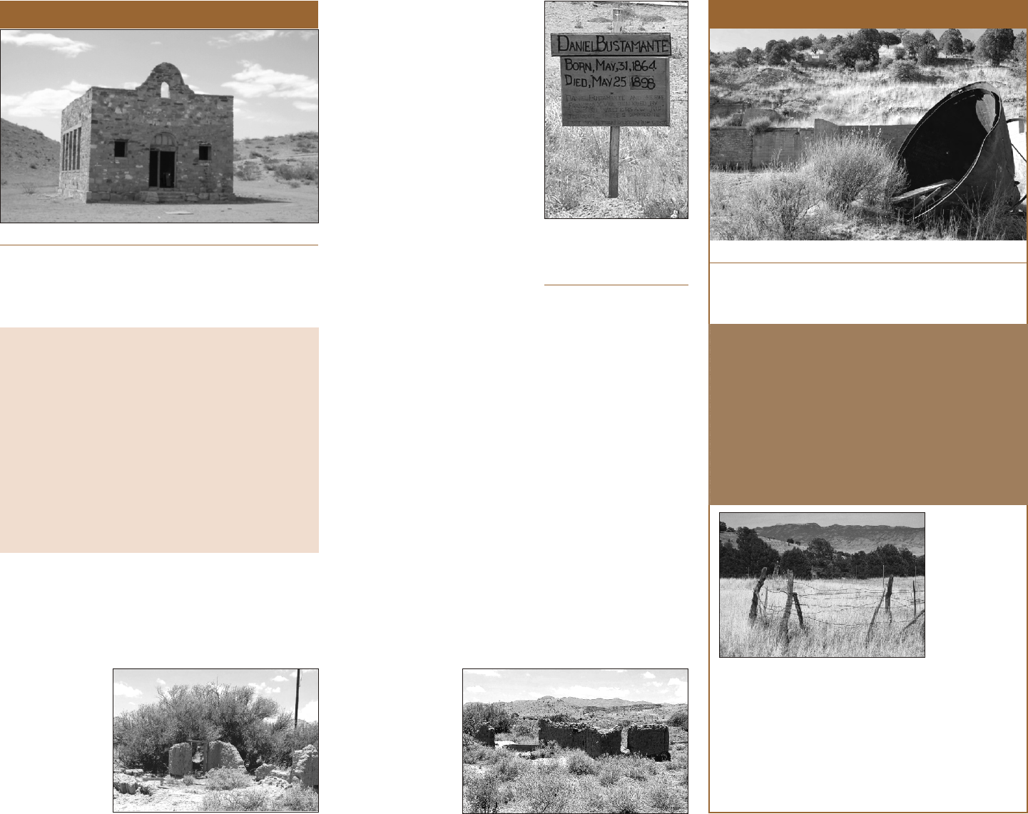
Not much is left of San Marcial. It was
completely destroyed by a flood in 1929. Still, it
attracts hundreds of visitors every year to see
the town that is no more.
Remnants of San Marcial near Black Mesa
San Marcial as it appeared three months
following the 1929 flood.
GPS: 33°42’12”N 106°59’02”W Elev. 4,500 ft.
Directions from Socorro: Take I-25 south, exit at San
Marcial, Exit 124. Drive east 1 mile to junction of
Highway 1. Note Confederate Monument. Continue
east on dirt road about 2 miles to rock water tank, buried
ranch house, a grave, and other remnants.
Travel: Year-round; most of travel on paved highways.
Last 2 miles on well maintained dirt road.
Advisories: The town site is a combination of Bureau of
Reclamation property, the Armendaris Ranch, and other
private land. No digging or treasure hunting allowed.
History: San Marcial was established shortly after
the Civil War and quickly became a center for
banking, mining and the AT&SF railroad.
Population was about 2,500. San Marcial was
completely inundated by a flood in 1929. The
nearby towns of Valverde, La Mesa, Plaza Viejo and
Geronimo were destroyed by a flood in 1937. These
towns, including the Valverde battlefield, now lie
under several feet of silt.
Courtesy of Socorro County Historical Society
There are many ghost towns and historical sites
in Socorro County from the pre-historic Piro
Pueblo culture, the early Spanish colonization
period (1598–1846), and others from the
Territorial days (1846–1912 statehood).
Most of these sites are inaccessible due to the
terrain, very poor roads (or lack of roads) –
leading to hazardous travel. Many sites are
virtually impossible to find without a guide.
Some sites are located on restricted federal
lands, closed private land, or protected because
of their high historic or cultural significance.
For your safety, visiting historic sites not
listed in this brochure is not recommended.
GHOST TOWN GUIDE
Socorro County
New Mexico
A Guide to some of
Socorro County’s Ghost Towns
Including
Socorro County Ghost Town Map
by Paul Harden
With specific travel directions to:
Ghost town of Riley (Santa Rita)
Mining ghost town of Kelly
Rosedale Mining District
The Graphic Mill
San Marcial
Fort Craig
1. Preservation. Please respect Socorro County’s
ghost towns and historic or cultural sites for
our future generations. Remember ...
TAKE only photos
LEAVE only footprints
2. Respect private property. Close cattle gates;
no firearms (don’t shoot at buildings, signs, or
water tanks); drive slowly around livestock.
3. Remoteness. Once you leave the paved
highways in Socorro County, you are entering
very remote country on dirt roads seldom
traveled. Be safe and be prepared.
4. Water. In summer months, temperatures can
exceed 100°F with single–digit humidity.
Take plenty of water to avoid dehydration.
5. Rattle snakes. Yes, we have rattle snakes.
6. Cell phone coverage is unreliable in most
rural areas.
7. Arroyos. Many dirt roads cross arroyos or dry
stream beds. During thunderstorms, arroyos
are prone to flash flooding. Crossing an arroyo
with a swift water flow can be deadly.
8. Notify. Let someone know where you are going
(friends, family, motel clerk, etc.) in the event
you experience problems and are delayed
reaching your destination.
9. Location. Know where you’re at and what road
you are on in case you need to seek help.
10. Travel at your own risk. Roads are generally
suitable for most automobiles – but not
recommended for RVs. Conditions can
change. Ask for current local conditions.
Grave of Deputy Sheriff
Daniel Bustamante,
killed by train robber
Broncho Bill Walters.
The school house at Riley, in use until 1953
Ruins of the
Pedro Aragon
home, built in
1882. The
Aragons were
the first family
to settle at
Santa Rita.
Ruins of the
Nuñez home.
The Nuñez sisters
operated a small
general store
from this adobe
building for many
years.
History: Riley was settled in 1882 by Pedro Aragon
from Polvadera. The small valley and springs at the
foot of Ladron Peak proved to be good farm land. The
Aragons were soon joined by other family and
friends from Polvadera. They named the town Santa
Rita, changed it to Riley in 1892 when they applied
residents reverted to calling the town Santa Rita.
In the 1940s, many of the men left to serve in World
War II, which further depleted the town of ranchers and
farmers. The school was closed when the Rural School
Administration was abolished in 1953. This forced the
remaining residents to move to either Magdalena or
Belen for schooling, where most of the former residents
live today. The Aragon, Romero, and Bustamante
families still live nearby.
The Santa Rita church remains an active mission
church to San Miguel parish in Socorro. A traditional
Spanish Mass is held once a year during the Santa Rita
fiestas on Memorial Day weekend. The fiesta serves as a
town reunion for former residents and their descendants.
Many remains of Santa Rita go unnoticed by most
visitors. They are located along the road running east
from the church. This becomes a rough road and use of a
high clearance vehicle is advised. There are several
structures along this road, including the old general
store, several homes and the small Protestant cemetery.
Riley is a ghost town, but the former residents keeps
its spirit alive and well today by keeping the old church,
built in the 1880s, in pristine condition and their annual
reunion and fiesta. Please respect the private ownership
and posted areas.
History: Gold and silver were discovered in 1882
when Nana’s band of Apaches still roamed the
San Mateos. A mining town quickly began. The
Rosedale Post Office operated from 1891-1928,
thereafter served by San Marcial. Rosedale was a
major gold and silver producer until the mine
played out in the 1930s. Buildings were
dismantled during the Great Depression and
abandoned by 1937. Much of the mine and
foundations of the mill remain.
RILEY (Santa Rita) ROSEDALE
GPS: 32°24’50”N 107°013’41”W Elev. 5,500 ft.
Directions from Socorro: Take U.S. 60 west to
Magdalena; turn north on Main Street (at old Bank
building), follow signs to Riley on County Road 354
(dirt). Immediately after crossing Rio Salado arroyo,
take right (east) road; drive ¼ mile to Riley.
Directions from I-25: Exit off I-25 at Bernardo, Exit 175
(25 mi. north of Socorro); drive west past RV park and
cell phone tower. After crossing historic Rio Puerco
bridge, turn right onto Socorro County Road 12 (dirt);
road leads directly to Riley – follow the signs.
Travel: Year-round; 2-wheel drive. Roads can be
hazardous during heavy rains or snow.
Advisories: Avoid travel during thunderstorms. From
Magdalena, don’t cross Rio Salado if flow is heavy.
for a post office (there was
already a Santa Rita at the
copper mines near Silver City).
Riley soon became known for
it’s pinto beans, peaches and
pears. Orchards were located
between Riley and the banks of
the Rio Salado.
The village of Riley, and
nearby Puertocito, were
popular stops for travelers
along the Rio Salado – the main
road from the Rio Grande to
eastern Arizona.
The water table and springs
began to dry up during the
1930s “dust bowl” years,
causing some of the residents to
move to greener pastures. The
post office was closed in 1931;
GPS: 33°48’29”N 107°24’18”W Elev. 7,150 ft.
Directions from Socorro: Take U.S. 60 west to
Magdalena then south on NM 107 about 24 miles to
Forest Road 330 (marked “Grassy Lookout”). Turn
right (west) on FR 330; cemetery is 5.3 miles up the
canyon; Rosedale Mine, and remnants of the mill, are
another 1/2 mile to the west.
Travel: NM 107 is a well maintained dirt road; FR 330 is
not and can be difficult with washouts following rain
storms. A high clearance vehicle is advised.
Advisories: Avoid travel during thunderstorms or in
snow.
Cemetery
includes the
grave of a
Fort Craig
soldier
killed by
Nana’s
Apaches in
1886.
Remnants of the Rosedale Mine and mill
Rosedale was a mining town. Remains of the
mine, foundations of the mill, a cemetery,
and scant signs of the town can still be seen.
Riley is one of New Mexico’s classic ghost
towns, located north of Magdalena, N.M. The
church and school mark the center of Riley, with
remnants of stores and houses scattered about.

The Kelly Church is
an active mission
church to San
Miguel parish in
Socorro. Dedicated
to Juan Bautista
(John the Baptist),
it is still used for
Mass, weddings,
funerals and the
annual fiesta.
Kelly’s Main
Street in the
1890s. Photo
courtesy of
Carlos Tafoya,
whose father and
grandfather
worked in the
Kelly mines.
Remnants of the
Graphic Mill. The
old concrete
structures once
supported the ball
mills, crushers,
and other heavy
machinery for the
mill.
The Ft. Craig sally port, or
entrance, during better days.
KELLY FORT CRAIG
History: Minerals were found in the area by John
Hutchinson in 1866. His claims were producing by the
1870s and spawned a small town at Pueblo Springs, now
called Magdalena. The post office was established in
1875. More lucrative claims were discovered farther “up
the mountain” and formed several mining camps. The
main camp was named after Hutchinson’s friend, Andy
Kelley, but misspelled “Kelly” when registered at the
Socorro County Courthouse in 1879. The district
exploded in the 1880s with many silver and lead mines.
The Kelly Post Office opened in 1883; the AT&SF
railroad arrived at Magdalena in 1885 and a daily stage
coach serviced Kelly. The grade was too steep to continue
the rail line to the Kelly mines. By the 1890s, the
population ranged between 1,500 and 2,000 residents.
The main ore mined was silver, lead, and zinc.
Taylor headframe and Tri-Bullion smelter at Kelly
Old Glory still flies from the old parade grounds
GPS: 33°38’00”N 107°01’07”W Elev. 4,520 ft.
Directions from Socorro: Take I-25 south to San
Marcial, Exit 124; follow signs. Drive east 1 mile. Note
Confederate Monument. Turn right (south) on paved
Highway 1, then south 6.2 miles. Turn left (east) onto dirt
road at sign for Fort Craig (at microwave tower). Fort
Craig is 4.5 miles further ahead.
Travel: Year-round; most of travel on paved highways.
Last 4.5 miles on well maintained dirt road.
Advisories: Call Socorro B.L.M. field office at
575–835–0412 for additional information. No artifact
collection, digging, or treasure hunting.
History. The first army fort in the region was Fort
Conrad, built in 1851 north of San Marcial (see
map). It was abandoned in 1854 to build Fort Craig.
GPS: 34°05’00”N 107°012’08”W Elev. 7,265 ft.
Directions from Socorro: Take U.S. 60 west 26 miles
to Magdalena; turn south on the Kelly Road at the U. S.
Forest Service Office. Drive south 2 miles to a fork in the
road. At the fork are the ruins of the Graphic Mill. Take
left-hand fork; Kelly is 1.5 miles ahead.
Travel: Year-round; road is steep and sometimes rough
and rocky, but suitable for most high clearance 2WD
cars (take it slow and easy – it only takes a few minutes
to arrive).
Advisories: Do not attempt road in winter with snow.
Snow can be deceivingly deep and hazardous to turn
around. Mines are still privately owned – no digging,
treasure hunting, or scavaging for minerals without
permission. Kelly Mine issues mineral permits at very
reasonable fees. Do not enter mine shafts!
In 1896, a railroad spur was extended to the foot of the
mountain when the Graphic Mill was built. The Sherwin
Williams Paint Company purchased the Kelly mine and
the Graphic Mill in 1904. The mill was destroyed by fire in
1916, and rebuilt the following year to process zinc and
lead from the Kelly and Waldo mines for paints.
The mines continued into the 1930s, when depleted
ore veins and the Great Depression took their tolls. A
swell of activity during World War II temporarily revived
the town.
The Kelly Post Office was closed in 1945, and the last
of the residents moved to Magdalena or Socorro by the
early 1950s. The abandoned town was dismantled for the
wood and bricks, which left only the mines and a few
buildings. An annual fiesta, held at the Juan Bautista
church, reunites the town’s residents.
Ft. Craig became
a major frontier
fort. It served as the
Department of New
Mexico during the
Civil War.
Historically, it is
well known for its
involvement in the
nearby Battle of
Valverde, fought
February 21, 1862, north of Black Mesa.
Today, Ft. Craig is a National Historic Site,
administered by the Bureau of Land Mangement.
The visitors area has restrooms and drinking water.
The fort is a self-guided tour and interpretive signs.
Kelly is another one of New Mexico’s best ghost
towns. Located just 3½ miles from Magdalena,
it is also very convenient to visit. Mines, head
frames, tailings, and remnants of mills and
smelters, remain of this once bustling mining
town.
Fort Craig was built in 1854 to protect travelers
along El Camino Real from attacking Apaches. It
was a major fort in New Mexico during the Civil
War and the Indian Wars. Interpretive signs
describe the fort and surviving structures.

Graphic
Mill
25
60
RILEY
169
KELLY
ROSEDALE
60
25
FORT CRAIG
380
60
1
25
0
3
R
F
3
SAN MARCIAL
o
i
R
S
a
l
a
d
o
t
t
t
t
t
t
t
12
12
354
107
107
Ladron
Peak
.
s
t
M
S
o
a
e
n
t
M
a
.
s
t
M
a
n
e
l
a
d
g
a
M
GHOST TOWN MAP of
Socorro County, New Mexico
e
d
n
a
r
G
o
i
R
Map by Paul Harden ©2009
Field
Ranching settlement
P.O. 1930–1939
Las Nutrias
Vegita
Abeytas
Puertocito
Trading post
P.O. 1909–1929
Sabinal
Est. 1741
P.O. 1866–1907
SOCORRO
Escondida
San
Pedro
Pueblito
San Antonio
Bosquecito
Luis Lopez
Lemitar
Est. 1830s
Polvadera
Est. 1830s
Alamillo
Est. 1803
Alamo
Historic Navajo
Community
Magdalena
La Joyita
Est. 1840s
destroyed by flood 1929
Park City
P.O. 1892–1894
Contreras
P.O. 1919–1943
La Joya
Historic
Camino Real settlement
P.O. 1871–1999
Bernardo
Trading post
settlement
P.O. 1902–1919
Council Rock
P.O. 1881–1882
Monica
P.O. 1881–1883
Adobe
Stage Stop
P.O. 1933
Lava
AT&SF RR settlement
P.O. 1886–1903
Paraje Fra Cristobal
Camp on El Camino Real 1598–1880s
P.O. 1867–1910
Gold
Barite
Galena
Copper
Copper
Silver
Silver
Uranium
Barite
Silver
Lead
Zinc
Silver
Maganese
San Acacia
1600s Hacienda &
AT&SF RR town
P.O. 1881–1982
Scholle
AT&SF RR town
Est. 1908
Ozanne
Stage Stop
P.O. 1906–1909
Oscura
Stage Stop
P.O. 1881–1882
Fraley
Limestone Quarries
and kilns 1890s
Carthage
Coal Mining Town
P.O. 1883–1935
Bingham
Ranch settlement
P.O. 1934–1994
Tokay
Coal Mining Town
P.O. 1917–1932
Valverde
P.O. 1897–1937
Destroyed by flood 1937
SanAntonio–White Oaks
Stage line (1881–1907)
Mockingbird
Gap
Apache Kid
gravesite
APACHERIA
Home to the Tchihene
(Warm Springs Apache)
under Chiefs
Victorio and Nana
and warrior Geronimo
X
X
X
X
X
X
1898 shootout
between train
robber Bronco Bill
Walters and posse.
Sheriffs Vigil and
Bustamante killed;
Navajo guide Guerro
Train robbery May 24, 1898
AT&SF Southbound Train #2
Bronco Bill Walters and Kid Johnson
Estimated take $30,000+
Lost Adams
Diggings
Originally named
Santa Rita
B-17 crash site
Oct. 15, 1942
9 Airmen killed
Battle of Valverde
Feb. 21, 1862
Confederate
Monument
Fort Conrad (site)
1851–1854
Black Mesa
(Mesa del Contadero)
El Camino Real trail
Used 1598–1890s
El Camino Real trail
Used 1598–1890s
Present day towns
Historic towns
Ghost towns
Roads
Paved
dirt
trails
AT SF & RR
A F
T&S
AT&SF Railroad
Arrived Socorro 1882
Suitable to visit
Bursum Road
to Mogollon
1890s–1920s
Socorro–
Magdalena
Stage Line
